Day 1Askham Sun 2 Aug
Day1 is being hosted by Border Liners Orienteering Club (BL) as a Long race.
Thanks to Lowther Estates and United Utilities for permission to use the area.
The area is open fell sitting between the villages of Pooley Bridge & Askham in the North Lakes.
Location Info
Near: Askham |
Postcode: CA10 2QA
Lat,Lng: 54.588,-2.761 |
Grid ref: NY509216
What3Words: cracker.clutches.owls
Open an interactive map and get directions in:
GoogleMap |
AppleMaps |
OpenStreetMap
Parking will be in fields south of the village of Helton, south of Askham and north of Bampton.
Assembly will be adjacent to the Parking fields.
Access is suggested from the village of Bampton Grange to the South.
This is because Lowther Castle & grounds are hosting the music festival "Kendal Calling" from July 30th to August 2nd.
Although all visitors are likely to be within the grounds some of the surrounding lanes my be closed or have diversions.
ENTRANCE TO PARKING 8.30am-12.00 noon
EXIT FROM PARKING 12.30pm onward
The assembly area is compact and therefore we are not planning on any specific priority parking.
PUBLIC TRANSPORT The nearest public transport stops in Village of Hackthorpe to the east of Lowther Castle.
CAMPERVANS/MINIBUSES/VANS.
Thomas the farmer has said that campervans may stay on the Saturday / Sunday nights. This must be by private, prior arrangement as the campsite will be closed to the public and the normal booking site (pitchup) will not be available. We anticipate the toilets will be delivered and available for use, there is fresh water but otherwise no facilities. Text message is preferred, the number is 07889 368933 (Thomas).
Starts & Finish There will be a single Start and Finish for all courses.
It will involve a walk of about 1.6km with 90m climb along the footpath onto the fell, crossing a couple of gates and a stile.
Uphill to the Start & downhill from the Finish.
There will be a Clothing Dump located near the Finish, which is about 600m before the Start.
The walk uphill took about 15mins, from the Car Park field to the edge of the fell near the Clothing Dump. The Start is another 5 mins or so.
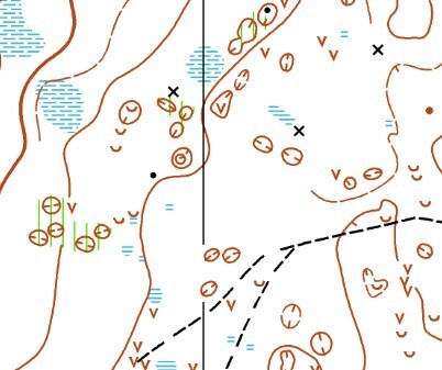
Planners comments
The small black circles O are old shooting butts. These consist of a ruined circular, or part circular wall about 6m in diameter 0.5 m high usually overgrown with grass etc. Some may be full of bracken and present as a knoll from a distance, some have converted into knolls and are mapped as such.
Rough Open land (most of the area) is shown as White on this map.
Bracken has come up very rapidly and strongly this year, we have tried to keep controls in locations that are free of dense bracken, or just a short distance in through light bracken, or occasionally wielded a sickle, though things may change in the month between submission of maps and the event itself. "On route" bracken will be visible on the ground allowing the competitor to make a route choice.
Many of the depressions contain animal warrens, nasty bogs and/or potentially hazardous junk. This could be an issue where obscured by bracken (which is often thick in the depressions). We will tape any hidden hazardous areas in depressions with controls in. We will also make sure the control is visible from the edge and clear round about. As a general rule keep out of uncleared bracken in depressions even if it means running round the rim.
There may be animals including sheep, cattle and horses on the competition area. Runners should avoid running directly at any animal.
Be aware of the risk of ticks and check yourself after your run.
The area is frequented by dog walkers, horse riders, cyclists etc. Please be courteous to everyone you meet.
All courses cross a road that runs along the south edge of the map, it is used to service a farm at the west end.
- Junior courses have a marshalled crossing which they must use to cross.
- Senior courses may cross the road freely with care,
Please do not run along the road.
Safety bearing is South to the road then further South to the wall.
Provisional course lengths given in the attached table:
| Course | Length km | Climb m | Start |
|---|---|---|---|
| 1 | 10.9 | 165 | Red |
| 2 | 8.6 | 160 | Red |
| 3 | 7.9 | 125 | Red |
| 4 | 7.6 | 130 | Red |
| 5 | 7.2 | 110 | Red |
| 6 | 6.8 | 105 | Red |
| 7 | 6.4 | 105 | Red |
| 8 | 5.9 | 100 | Red |
| 9 | 5.8 | 50 | Red |
| 10 | 5.6 | 55 | Red |
| 11 | 5.1 | 50 | Red |
| 12 | 4.9 | 40 | Red |
| 13 | 4.0 | 40 | Red |
| 14 | 2.8 | 20 | Red |
| 15 | 5.5 | 75 | Red |
| 16 | 3.9 | 40 | Red |
| 17 | 3.4 | 25 | Red |
| 18 | 3.0 | 25 | Red |
| 19 | 1.9 | 10 | Red |
Map
Original map based on Stirling Surveys photogrammetry
Updates by Dan Parker for Lakes 5 Days 2026.
© Border Liners Orienteering Club 2026.
Officials
| Organiser | Ali Lea | BL |
| Planner | Paul Watson | BL |
| Controller | Lindsey Knox | RR |
Old Maps
Askham was used in the 2018 edition of Lakes 5 Days.
The old map can be found on Routegadget here.