
Day 4Bigland Thu 6 Aug
Day4 is being hosted by Deeside Orienteering Club (DEE) as a Middle race.
Bigland is a wooded slope to the south of the village of Haverthwaite.
Thanks to Mr Wilkinson, Mr Klijn & Mr Fell for permissions to use their woods.
Thanks to Mr Doug MacDonald, Bigland Estate Manager for all of his help.
Location Info
Near: Low Wood |
Postcode: LA12 8PA
Lat,Lng: 54.2445,-2.9921 |
Grid ref: SD354836
What3Words: demanding.offerings.mended
Open an interactive map and get directions in:
GoogleMap |
AppleMaps |
OpenStreetMap
Key Points
• Travel: Please allow plenty of time to travel to the event, to get from parking to assembly (1.2k from main car park with 80m climb) and to then get to your start (Blue 1k and Red 1.25k, both 70m climb).
• Large Vehicles: (that’s taller than a VW camper van) should use the on-street parking on Old Barrow Road (just past the Anglers Arms - opposite Haverthwaite Railway) and the 2k route to the assembly will be marked. This is because of overhanging branches at the entrance to the bottom parking fields that may damage your vehicle.
• Toilets: There will be toilets and a urinal in the main car park as well as at Assembly. There will be no toilets at the start.
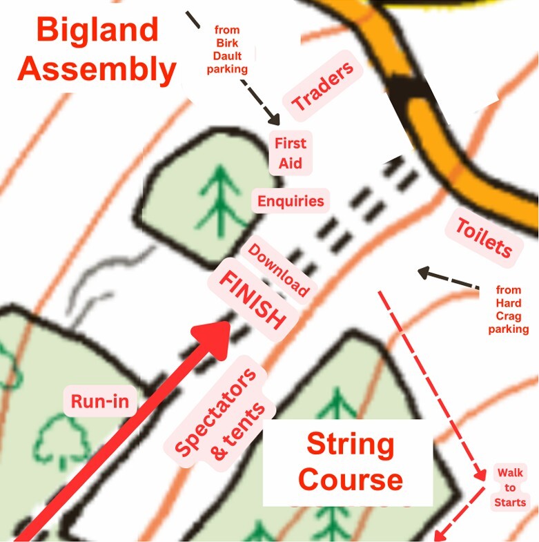
• Assembly: See image for the assembly layout, which includes the finish for all.
• Club Tents: The slope below the String Course is a great spot to site your club tents and cheer on your club members as they finish.
• String Course: The string course is in the wood above the run-in, beyond the club tents.
• Walk to Starts: The route to both starts is up hill from the assembly area and will be marked with RED tape & BLUE tape for each respective start.
• Clothing Dump: There is no clothing dump at the start – finish in Assembly.
• Water: If you take a drink with you to the start, please ensure that it is emptied & placed in the binbags provided. Sorry, no water will be provided
• Bigland Tarn: The tarn is OOB and swimming is not permitted.
• Litter: Please have a good look round your vehicle when you leave and take all litter away with you. Our use of this fabulous area is reliant on the goodwill of landowners.
• Public: Please note that there is a public right of way that crosses the area.
Have a great day and enjoy this super orienteering woodland.
Iain Bell (DEE)
Day 4 Organiser
Parking
Will be in 2 locations. Flat fields at Birk Dault, Low Wood (below Assembly) and a sloping field at Hard Crag Farm (above Assembly).
Access to both Car Parks is via the A590 to Haverthwaite x-roads where you turn south. (SD340842 - Post Code LA12 8AD - W3W like.allowable.thankful).
ENTRANCE TO PARKING 8.30am-12.00 noon
EXIT FROM PARKING 12.30pm onward
Large Main Car Park - Birk Dault
Suitability: This is the main Car Park and is suitable for cars and moderately sized campervans , minibuses and vans (up to 2m in height) .
If you are bringing a very large vehicle there is on street parking on Old Barrow Road (just past the Anglers Arms) opposite the Haverthwaite Railway Station.
Directions: Follow the road around into Low Wood and immediately on crossing the River Leven turn right (West) down Fish House Lane (SD345836 - Post Code LA12 8LY - W3W swim.sourcing.handlebar). Follow signs to parking fields within a couple of hundred metres.
The route to Assembly will be a marked from the Low Wood river bridge. Distance is 1.2km with 80m of climb on woodland paths. This route is unsuitable for push chairs.
There will be limited toilets in this car park - main toilets in Assembly.
Small Car Park - Hard Crag
Suitability: This Car Park is suitable for cars. Should be used by older competitors & families with young children.
Directions: Follow the road around into Low Wood and immediately on crossing the River Leven turn left (East) towards Low Wood hamlet (SD345836 - Post Code LA12 8LY - W3W swim.sourcing.handlebar). Continue up the road past Assembly and shortly before the top of the hill you turn left into the drive of Hard Crag farm and immediately turn into the parking field (SD358835 - Post Code LA12 8AQY - W3W roadshow.sitting.stud).
The route to Assembly will be a marked from the bottom of the Parking field. Distance is about 500m with 50m of descent (climb on the return).
Priority Parking
Unfortunately, there is no Priority Parking as we were unable to secure a field adjacent to Assembly. However participants may be dropped off at the Assembly gate en route to parking at Hard Crag Farm. Please avoid creating an obstruction to the flow of traffic on this single track road.
Public Transport
The nearest public transport is X6 bus which stops at Haverthwaite Station.
Assembly
Is in a large field beside the road up Bigland hill (SD354836 - Post Code LA12 8PA - W3W demanding.offerings.mended).
Starts & Finish
Blue (Near) Start for courses 8-19
1km from the main arena, with 70m climb.
Red (Far) Start for courses 1-7
1.25km and 70m climb. This is a further 250m along a flatter section of the track from the Blue start
Allow up-to 20 minutes.
There will be no clothing transfer back from the Starts.
Finish
There is a single Finish which will be in Assembly.
Planners comments
All courses other than White make use of the wonderful, rocky technical challenge that are Bigland woods. Overall, the forest is open and offers fast running … if you’re not going uphill! There are patches of low visibility and slower going due to some enthusiastic holly growth and the planner may or may not have taken advantage of these areas. Any clearings in the forest will inevitably be inhabited by bracken and you may want to pick your routes with that in mind.
The White course uses large paths in open fell and some open fields.
Some extra notes for the Blue (near) start:
The Blue start will be in an area of open fell. There is a bird pen on a main path within this area that some courses will pass close by. Please DO NOT run on the path adjacent to the bird pen as this will spook and stress the birds. The area is marked as out of bounds and the path will be blocked by tape and signs – divert around this path.
The bracken has been particularly virulent this year on the lower slopes and this has affected the courses to some extent. In a rare fit of generosity, DEE volunteers have attacked areas of the stuff with strimmers, machetes and billhooks to blast rat-runs along some of the more likely route choices. If you find yourself pushing through head-high bracken, there’s a good chance you’re not on an optimum route!
There is a path network within the open fell. Marked paths can generally be distinguished from our rat-runs by having been mown and with grass underfoot.
Some extra notes for the Red (far) start:
All these courses are in woodland, including the superb High Stribers Wood. Before you get too smug, there are some glades and clearings with bracken – however these can generally be avoided with some judicious route choice through the forested areas.
Courses 1 and 2 enter a fantastic area of wood via a temporary stile over a new fence with a barbed top-wire. You MUST use this stile.
Competitors will exit the area via an open gate.
All Red start courses will cross a semi-ruined fence and wall.
At its southern end, the fence is fairly intact and has a barbed top-wire. Two crossing points have been created and are marked on the map.
Further north, the fence is more broken and ways over, under or around can be found … here the fence is not marked as an uncrossable boundary.
There is a gap in the wall at the top of the hill also marked as a crossing point which can be used with a bit of athleticism and care.
Course lengths and start location
| Course | Length km | Climb m | Start |
|---|---|---|---|
| 1 | 5.2 | 240 | RED |
| 2 | 3.9 | 240 | RED |
| 3 | 3.4 | 200 | RED |
| 4 | 3.6 | 180 | RED |
| 5 | 3.3 | 175 | RED |
| 6 | 3.3 | 155 | RED |
| 7 | 3.1 | 150 | RED |
| 8 | 2.7 | 130 | BLUE |
| 9 | 2.7 | 130 | BLUE |
| 10 | 2.6 | 135 | BLUE |
| 11 | 2.3 | 110 | BLUE |
| 12 | 2.4 | 90 | BLUE |
| 13 | 2.1 | 65 | BLUE |
| 14 | 1.9 | 50 | BLUE |
| 15 | 2.5 | 110 | BLUE |
| 16 | 1.9 | 85 | BLUE |
| 17 | 1.9 | 50 | BLUE |
| 18 | 1.8 | 35 | BLUE |
| 19 | 1.6 | 30 | BLUE |
Map Data
All courses are at a scale of 1:7500 and 5m contours.
Original map by Stirling Surveys 1992
Lidar and other updates by Martin Bagness for JK2023, British Relays 2025 & Lakes 5 Days 2026.
© Lakeland Orienteering Club 2026.
Old Maps
The area was last used for the 2025 British Relay Champs.
Link to the map on British Champs Routegadget page is here
Officials
| Organiser | Iain Bell | DEE |
|---|---|---|
| Planner | Jon Hateley | DEE |
| Controller | Patrick Smyth | NATO |