Day 5Hampsfell Fri 7 Aug

Day5 is being hosted by South Ribble Orienteering Club as a Long race.
Hampsfell is an area of Limestone pavement above Grange-Over-Sands.
Thanks to the Holker Estate & Forestry England for permissions to use the area.
Location Info
Near: Field Broughton |
Postcode: LA11 6HL
Lat,Lng: 54.2221,-2.9261 |
Grid ref: SD397811
What3Words: speeds.goodbye.wonderful
Open an interactive map and get directions in:
GoogleMap |
AppleMaps |
OpenStreetMap
Day 5 Key Points
• Website – the website details for Day 5 have been recently updated. Please make sure that you read them again. These final details only include the key points for the event.
• Approach – please approach from the A590 at Low Newton and follow signs towards Cartmel. This will allow an orderly entry to the event.
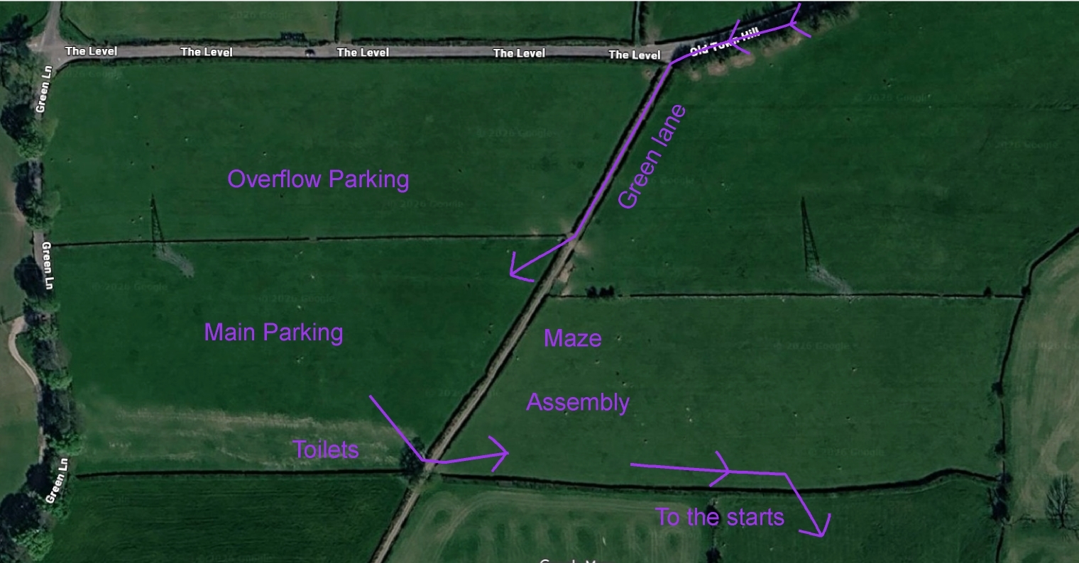
• Large camper vans – we believe that all vehicles should be able to get into the main parking field via a green lane. If you really cannot, then please carry on to the next road junction and follow signs to an alternative field which is 500m walk to Assembly.
• Priority parking and helpers – please make yourselves known to the parking team so that they can direct you to the right place to park.
• Maze. will be open for younger competitors in the Assembly area from approx. 10:30– 14:00.
• Start and finish – the route to and from the start and finish have changed. They are now slightly shorter at:
600m and 80m of ascent to the two starts
850m and all downhill back from the finish
• Mandatory equipment – all competitors must:
Wear full leg cover which is mandatory (Full arm cover and gaiters advised).
Carry a whistle
• Clothing Dump. There is no clothing dump - leave your bags in Assembly.
• Wall crossing - Walls overprinted with a purple line must only be crossed at designated crossing point. These are shown either as gaps in the purple line or with a purple crossing point symbol.
• Cattle - There will be cattle grazing on parts of Hampsfell. The cattle are docile and used to people. Please don’t expect them to move out of the way and keep a safe distance.
• Cattle trods – the cattle have recently been active in making a lot of new trods in some areas. These can look like paths but are not marked on the maps. The path is usually obvious but be aware.
• Ticks – May be present in the area. Consider checking for ticks after the event.
• Gates – If you pass through a gate that is closed, please reclose it after you.
• Safety Bearing - Head north towards finish or start. There are many footpaths and this is the obvious direction.
• Departure - no departures before 1230 or maybe even a bit later.
• Prize Giving - will be in Assembly at 3:30pm.
Enjoy the final day and I hope it is a fitting end to your week.
Les Davies (SROC)
Day 5 Organiser
Parking
will be in two fields to the east of the hamlet of Field Broughton, north of Cartmel.
Parking will not be open until 9.00. Please do not arrive before then.
Access is via the A590 junction at the top of Lindale Hill near Low Newton. (SD405816 - Post Code LA11 6LZ - W3W hails.sizes.recording), signposted to Cartmel and Low Newton. If you are travelling from the north/west, ignore the turning on the single carriageway road at the bottom of the hill marked Cartmel and Holker. From the A590 junction follow the signs to Cartmel, west down Cartmel Lane onto Old Town Hill for about 750m.
There will be signs directing you to turn left onto a narrow green lane which you follow for 150m before turning into the Parking fields.
The green lane is only wide enough for one vehicle. We need to have a one-way system for entry to parking. Exit will only be possible after we are confident that everyone has got in and hence you may not be able to leave until 12:30.
For large camper vans, if you can get into the green lane, you will be able to get into the camping fields. We believe that this will be possible for all vehicles.
In the unlikely event that you cannot get into the green lane, continue to the next junction and turn left, and you will be directed by signs to an alternative field. This will not be marshalled, so please park considerately. It is then a 500m walk back to Assembly from the other end of the green lane which will be signed.
Public Transport
The nearest public transport is X6 bus which stops at Yew Tree Barn in High Newton. It is just over a mile walk from the bus stop to Assembly.
Assembly
will be adjacent to the Parking fields at the Eastern end of the Southern field.
Club tents and flags can be erected next to Assembly.
Starts & Finish
There will be two Starts and one Finish.
The route to both Starts, and return from the Finish, follows the footpath up the fell for about 650m
Both Starts have about 80m of climb.
Total distance 850m with 80m climb from the main arena.
Allow up-to 20 minutes.
There will be no clothing transfer back from the Starts or to the Finish.
Blue Start
Will be about a further 200m onto the fell.
Red Start
Will be about a further 250m onto the fell.
Finish
There is a single remote Finish which is also around 800m from Assembly.
Uphill to the Start & downhill to the Finish.
Planners comments
The area is a mixture of rough open fell, patchy young forest growth and mature Eggerslack woods, separated by stone walls. The underfoot conditions are varied and range from easily runnable open terrain on the middle and southern part of the competition area, to slow and steep rocky ground in the eastern woods that only the longest courses will venture into.
There are large patches of open limestone and stony ground throughout Hampsfell that are generally more difficult to run on than rough open land. Open limestone pavement has deep fissures that may be overgrown with grass. If it rains on the day of event, additional care should be taken when running on the footpaths going through well-worn bare rock – these may become extremely slippery.
The walls are only crossable at the designated crossing point and will be overprinted with a purple ‘Uncrossable boundary’ line. Most crossing points will be marked with the purple ‘Crossing point’ symbol but a few are just shown by a gap in the purple line. Most of the crossing points are existing gates and stone steps. Additionally, there will be 3 sets of ladder stiles, one of which will be crossed by all the courses.
On Course 14 maps, two of the optional ladder stiles will be labelled in case competitors who might find them difficult want to choose routes that avoid them.
There will be cattle grazing on the northern part of Hampsfell and competitors crossing the walls through the gates MUST leave them closed to prevent the cattle wandering off. The cattle are docile and used to people, please don’t expect them to move out of the way and keep a safe distance.
One of the crossing points has a permanent ladder stile next to metal gates. These gates may be locked, in which case please use the stile to cross the wall, or may be left open, in which case please don’t try to close them – more information will be provided at the start. This potentially affects all but the shortest (14, 18, 19) courses.
Courses 1, 3 and 4 will have double-sided maps.
Full leg cover is mandatory. Full arm cover and gaiters advised.
If lost, head North towards the Start or Finish.
Map & Terrain
Bracken is shown on the map as ‘Undergrowth – slow run’ vertical green hashing and can vary from waist-high ferns on the open, exposed fell, to over 2 metre tall ferns in shady re-entrants. These are somewhat patchy and should not be relied on exclusively for navigation.
Areas of brambles and bramble overgrown with bracken are marked with ‘Undergrowth – walk’ closely spaced green hashing. Again, these are seasonal and their exact area might vary slightly.
Some small footpaths and cattle trods tend to appear and disappear and are not mapped.
In areas with no trees limestone pavement is shown with the ‘Bare rock’ symbol (continuous grey). In areas with trees (either woodland or rough open with scattered trees) , the ‘Stony ground’ symbol (small black dots) is used instead. However if there are just a few solitary trees, be prepared for either symbol.
Provisional course lengths and start location
| Course | Length | climb | Start |
|---|---|---|---|
| 1 | 8.9 | 325 | Red |
| 2 | 7.3 | 305 | Red |
| 3 | 6.5 | 265 | Red |
| 4 | 5.7 | 265 | Red |
| 5 | 5.4 | 265 | Red |
| 6 | 5.2 | 215 | Red |
| 7 | 5.3 | 220 | Red |
| 8 | 4.9 | 160 | Red |
| 9 | 4.6 | 155 | Red |
| 10 | 4.3 | 175 | Red |
| 11 | 4.1 | 130 | Red |
| 12 | 3.8 | 130 | Blue |
| 13 | 3.1 | 120 | Red |
| 14 | 2.2 | 80 | Blue |
| 15 | 4.3 | 150 | Red |
| 16 | 3.2 | 115 | Blue |
| 17 | 2.5 | 85 | Blue |
| 18 | 2.1 | 60 | Blue |
| 19 | 1.5 | 40 | Blue |
Map Data
Courses 1,2,3,4,6 & 10 are at a scale of 1:10000 and 5m contours.
Courses 5,7,8,9 & 11-19 are at a scale of 1:7500 and 5m contours.
Original map based on Stirling Surveys photogrammetry
Updates by Martin Bagness for Lakes 5 Days 2026.
© South Ribble Orienteering Club 2026.
Old Maps
Hampsfell & Eggerslack Woods were used in the 2014 Lakes 5 Days..
Link to that map is here
Officials
| Organiser | Les Davies | SROC |
|---|---|---|
| Planner | Simonas Sakalauskas & Fraser Dixon | SROC |
| Controller | Dan & Karen Parker | BL |